Trip details
On this page, you will find everything about the individual trips taken.
Route
Check out the route recording of each day
Information
Take a look at the individual parameters of each travel day
Videos
Check out videos of the best sections of the route
Did you know?
Read about the most interesting route points and stops along the way

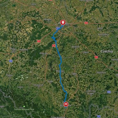
15.04.2025 Landshut - Pilsen
Pathos
Distance: 209 km
Driving time (non-stop): 3:57 h
Total travel time: 5:21 h
The route was very enjoyable to drive, although it presented some challenges at times, as it led over very narrow roads that were occasionally in poor condition or used by other vehicles, such as tractors, which significantly slowed down the journey. In some places, the visibility was so limited that speed had to be greatly reduced, as many of the roads were contaminated, mainly with stones and gravel, but sometimes also with agricultural residues or old oil traces.
Overall, the route was very pleasant to drive, offering a nice mix between small agricultural paths and larger roads. Highways were completely avoided on this route.
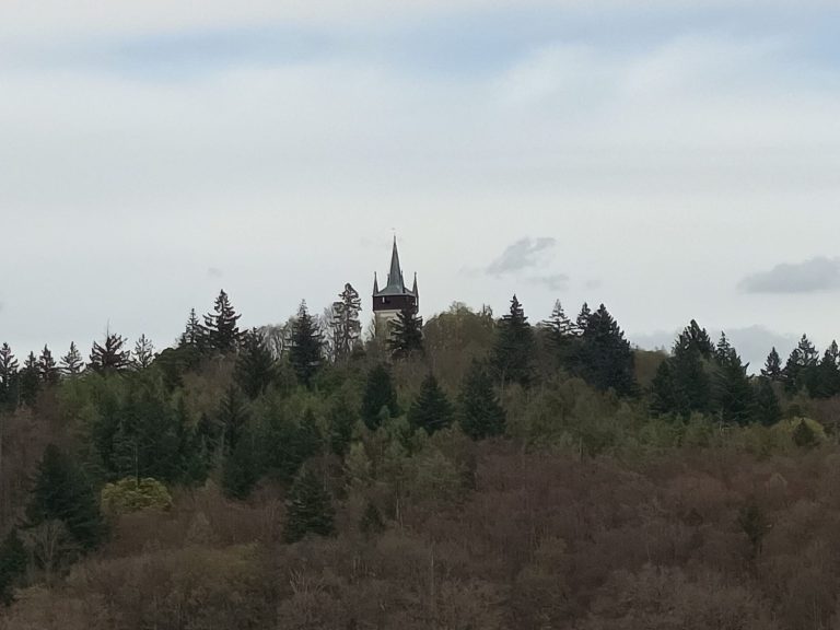
A particularly beautiful section of the route was just across the border in the Czech Republic. Between the towns of Kdyně and Němčice, there's a small hill that you ascend through the forest. Along the way, you encounter some fairly challenging curves that are very tight and at times quite blind. This stretch is a great opportunity to show how well you can handle your machine.
17.04.25 Pilsen - Prague
Distance: 124km
Driving time (non-stop): 3:54 h
Total travel time: 4:17 h
The drive from Pilsen to Prague started off quite relaxed—once you found your way out of Pilsen, that is. The route passed through many villages with beautiful landscapes and winding roads that are a real treat for motorcyclists.
Outside the villages, the roads are generally in perfect condition. However, as soon as you cross into a village, it becomes a challenge to dodge the many potholes and milling edges. There are lots of construction sites along the way in the villages, which can occasionally lead to a bit of waiting time.
The entry into Prague really drags on toward the end due to heavy traffic and frequent traffic lights. You also have to brake often, as pedestrians tend to cross the street unexpectedly. Finally, there’s the challenge of finding parking—something that’s not only difficult but also very expensive, especially around the Old Town.
If you're staying in Prague, it's probably cheaper to book a hotel that includes parking in the price, rather than using one of the public garages.
Another thing I hadn’t considered: my GPS routed me onto a ferry crossing. As much as I would’ve enjoyed those 20 meters over the river, unfortunately, I didn’t have any cash on me, and the €0.20 fee couldn’t be paid by card.
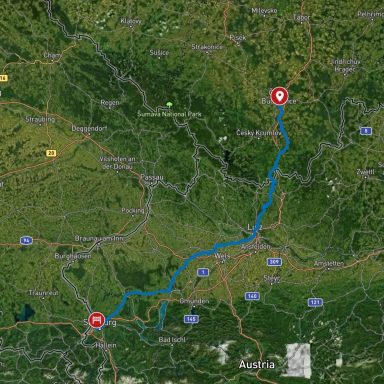
20.04.25 Prague - Budweis
Distance: 177 km
Driving time (non-stop): 3:54 h
Total travel time 7:40 h
Leaving Prague turned out to be just as tedious as entering it. The combination of cobblestones, tram tracks, and occasionally very large potholes is definitely a strain for both rider and machine. On top of that, you often can’t drive as fast as the speed limit allows, which sometimes makes the drivers behind a bit impatient.
As soon as you get out of the city, the ride becomes much more pleasant — the roads are once again well-suited for motorcycles. Unfortunately, due to the frequent winding sections, you often find yourself stuck behind a slow car or a tractor, which takes away from the joy of the ride a bit.
The parking lot for Karlštejn Castle is located in the town of Karlštejn, meaning it’s well-paved and even has specially marked motorcycle parking spots — although that doesn’t affect the ticket price (around €4). If you’re not carrying too much gear, you can also park in a small area right in front of the restaurant, which isn’t part of the paid parking zone.
22.04.25 Budweis - Salzburg
Distance: 261 km
Driving time (non-stop): 6 h
Total travel time: 8:09 h
The GPS seemed to have a few issues today. Not only did it direct me twice onto roads that were clearly closed due to long-term construction work, but it also showed me a route that didn’t even exist—once involving a railway crossing.
So there was no other option than to either accept a detour of a few kilometers or drive a few hundred meters along a dirt track next to the railway tracks, until I finally reached an underpass and was able to continue on my way.
The border crossing into Austria was also quite interesting. One moment I was driving on a very bumpy road in the Czech Republic that resembled more of a paved hiking path, and the next moment I was standing in front of the sign marking the Austrian border.
All in all, a very interesting experience. The biggest difference between the two countries is definitely noticeable in the condition of the roads and buildings in the various towns
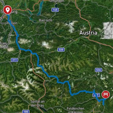
24.04.25 Salzburg - Friesach
Distance: 256,3 km
Driving time (non-stop): 5:24 h
Total travel time: 7:23h
Today was a challenging day for riding—the wet and cold weather combined with lots of curves and elevation changes, along with highly variable temperatures, made the ride quite difficult.
Normally, the route from Obertauern into the Metnitz Valley would be a dream for any motorcyclist, thanks to its scenic setting and interesting road layout.
Since my accommodation was located up on a mountain, I had one more task to face at the end of the day: making it up the mountainside safely (400 meters of elevation gain over about 4 km). A storm had swept through the area last year, leaving the road in poor condition. Add in the rain and a nearly continuous line of gravel running down the middle of the narrow road, and it became a real challenge. You can find the full video of the ride uphill here.
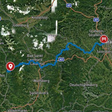
26.04.25 Friesach - Graz
Distance: 114,3 km
Driving time (non-stop): 3:03 h
Total travel time: 3:03 h
The weather hadn’t improved much—it was still wet and cold—but once again the route led quite far uphill.
The first leg of the journey took me to Klippitztörl, at just over 1,600 meters. Since you gain and then lose altitude quite rapidly, the changing pressure plays tricks on your ears. All in all, it’s a very beautiful stretch of road—though it would be even more spectacular in the sunshine
The ride into Graz was interesting in that it initially felt like entering a small village. You're still half in the forest, navigating a few switchbacks, and then suddenly, you're in the middle of Graz.
The part of the city I stayed in had lots of construction sites, which you need to watch out for, along with one-way streets and turn restrictions that made navigating a bit trickier.
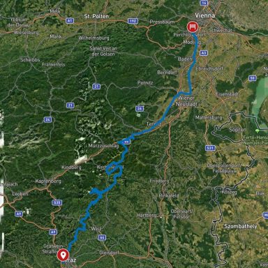
27.04.25 Graz - Vienna
Distance: 255,3 km
Driving time (non-stop): 5:37 h
Total travel time: 6:57 h
Thanks to the good weather, I set the GPS to a winding route, which led to lots of small roads, tons of ups and downs, great curves, and fantastic views.
With the nice weather, though, there were also lots of hikers and cyclists out and about, which sometimes meant I couldn’t take the curves quite the way I would have liked to.
Another issue with roads off the main routes is the frequent presence of debris on the pavement, mostly in the form of loose gravel — often small piles on the edges, but sometimes large patches — or remnants from farm activity. That can turn into a slippery hazard pretty quickly on a day like today, especially when the road hasn't completely dried in the shaded areas.
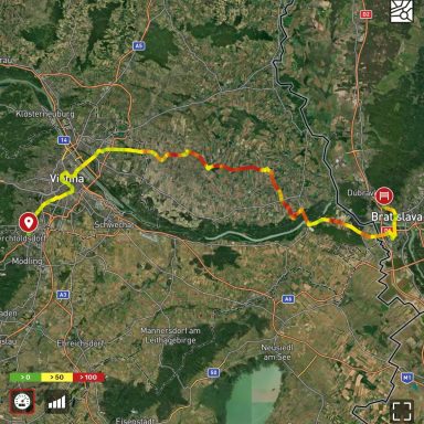
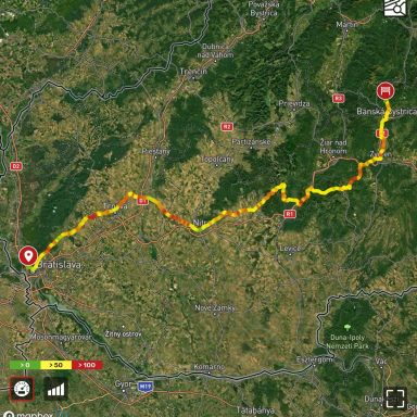
30.04.25 Vienna - Bratislava
Distance: 95,1 km
Driving time (non-stop): 2:03 h
Total travel time 2:54 h
Since I didn’t pass through Vienna on my way in, I made up for that today. It's not an experience I’d necessarily recommend — driving through Vienna is fairly exhausting and confusing. On top of that, there are tram tracks and horse-drawn carriages (Fiaker) to watch out for.
Still, it’s a nice way to pass by some of Vienna’s most beautiful spots one last time.
The way to Bratislava is quite short, takes less than two hours, and mostly crosses very flat terrain — you can really tell you’ve left the Alps behind. There are lots of wind turbines and the occasional small village. The time of mountain passes and hairpin turns is definitely over here.
Driving in Bratislava itself is a bit tricky — the exits from the main roads are sometimes poorly marked or not marked at all, so you need to either know where you're going or trust your GPS.
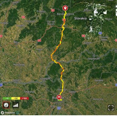
02.05.25 Bratislava - Banska Bystrica
Distance: 247,9 km
Driving time (non-stop): 5:07 h
Total travel time: 5:55 h
After two half-days of riding on flat terrain, today took me into the western foothills of the Carpathians, which meant I finally got to enjoy more curves and inclines again.
The very first longer stretch of curves was quite challenging—it required a lot of shifting, especially because I had a car in front of me that was struggling a bit with acceleration in the corners. Still, it was nice to have a bit of a driving challenge again.
The bigger problem came at the end of the ride when trying to reach my accommodation, because the road leading there has no name and therefore couldn't be found by the GPS. So I was only able to navigate to the nearest town, and from there I had to rely on Google Maps.
The road itself turned into a bit of an adventure too, because right in the middle of a curve, the nice asphalt ended and turned into a mix of large potholes and gravel.
05.05.25 Banska Bystrica - Budapest
Distance: 191,9 km
Driving time (non-stop): 3:21 h
Total travel time: 5:46 h
Driving down the mountain road in the rain wasn’t exactly fun either. Apparently, there had been a storm during the night strong enough to break some branches off a tree, which were now scattered across the road, posing an additional obstacle.
The route through Banská Bystrica wasn’t much of a joy either—the road surface always seemed to be damaged in the worst possible places.
After Zvolen, there’s a beautiful stretch of country road that winds through mountains and forests. It’s a lovely, curvy route with an excellent road surface and clear visibility.
Unfortunately for me, a tractor followed by about half a dozen trucks were ahead of me, so I couldn’t enjoy that stretch of road properly.
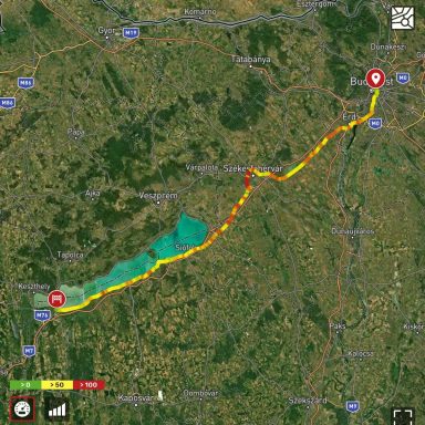
08.05.25 Budapest - Lake Balaton
Distance: 183,4 km
Driving time (non-stop): 3:44 h
Total travel time: 4:10 h
Driving in Budapest can be a bit confusing and annoying at times, mainly because you often have to take long detours due to the many one-way streets.
On top of that, the traffic lights are positioned in a way that you only notice them quite late, and their timing is unfortunate — it feels like you're forced to stop every 100 meters.
Driving along Lake Balaton sounds great at first, but unfortunately, you rarely get to actually see the lake. As with many large lakes and seaside roads, there's usually a row of houses between the road and the water that blocks the view.
Still, there are occasional spots where you can get right up to the lake — but if you're unlucky, you'll end up having to turn around on a tiny gravel path.
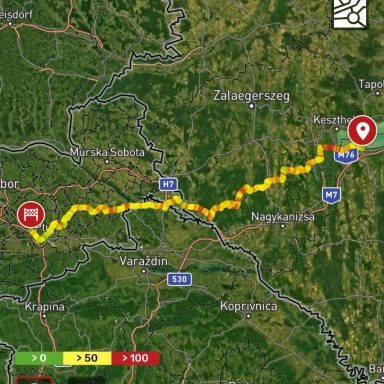
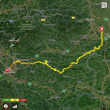
09.05.25 Lake Balaton - Ptuj
Distance: 174,5 km
Driving time (non-stop): 3:31 h
Total travel time: 3:58 h
Along Lake Balaton, the ride was rather uneventful—mostly straight roads with hardly any elevation changes.
That changed after crossing into Slovenia, where there were plenty of curves and inclines again, and the road quality significantly improved compared to Hungary. Only right after the border there was a two-kilometer stretch of gravel road, as construction work was underway.
Interestingly, the GPS didn’t just take me straight to Slovenia—it also included a small detour through Croatia. So the route went from Hungary to Slovenia (just a few kilometers), then into Croatia (also a short distance), and finally back into Slovenia.
With a route like that, I’m glad border checks are a thing of the past.
Gallery
Diary
10.05.25 Ptuj- Ljubljana
Distance: 197,7 km
Driving time (non-stop): 5:11 h
Total travel time: 6:21 h
Today's route had everything a motorcyclist could wish for: lots of curves, great views, and some challenges—especially when it came to mastering extremely tight curves combined with steep inclines.
There was plenty of that today: curves between 100° and 150°, with elevation changes of 3 meters or more over just 5–8 meters of road.
The stretch past Dolena was one of the most beautiful sections (video 1), with fantastic curves and an excellent road surface—riding there was a lot of fun.
Unfortunately, right after that came probably the worst part of the route, where the road was a patchwork of asphalt bits, potholes, and lots of loose gravel. Luckily, that part was short, and the road improved significantly afterward. From up in the mountains, there was a great view thanks to the lovely weather.
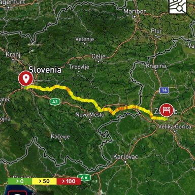
13.05.25 Ljubljana - Zagreb
Distance: 161,4 km
Driving time (non-stop): 4:19 h
Total travel time: 5:52 h
Today there were some great winding roads again, although at one point I leaned a bit too far into a curve and my footpeg scraped very loudly against the asphalt.
At least that answered the question of whether the side cases are high enough and don’t touch the road when I take a corner a bit too tightly.
The entrance into Zagreb was interesting, especially because I’m quite sure the GPS led me down a route I probably wasn’t supposed to take.
Apparently, I drove against traffic on a one-way street for a while, and on a lane that was reserved for buses and taxis only.
In the end, I still made it there and didn’t get stopped by the police.
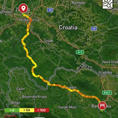
16.05.25 Zagreb - Banja Luka
Distance: 224,1 km
Driving time (non-stop): 4:40 h
Total travel time: 5:23 h
The roads in the Croatian hinterland heading toward Bosnia are very beautiful, but also a bit annoying. The towns are huge and basically blend into one another, which means you’re technically only allowed to drive 50 km/h everywhere.
But no one seems to care—everyone drives too fast. It’s the same in Bosnia. There, you're treated like the worst nuisance on the road if you drive under 70 in built-up areas. In general, people here have a rather unconventional approach to following traffic rules
In Banja Luka, there was an issue with the GPS. Even when entering the correct address, it led me to a different street. In the end, I had no choice but to bite the bullet and turn on expensive data roaming.
That finally led me to the right address—via a path that was most likely a pedestrian walkway with physical barriers. Thank goodness I was on a motorcycle—you couldn’t have taken that route with a car.
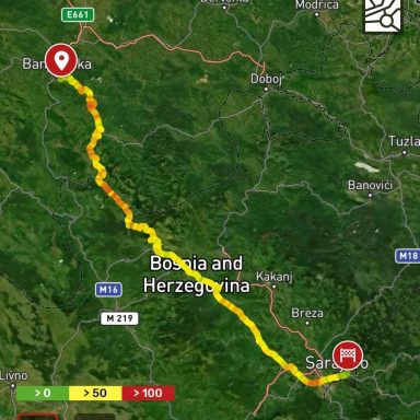
17.05.25 Banja Luka - Sarajevo
Distance: 199,5 km
Driving time n(on-stop): 4:32 h
Total travel time: 5:58 h
The descent after Galica was one of the most challenging stretches I’ve ridden so far—with a dirty road surface, narrow lanes, lots of curves, and pretty much no guardrails.
The view over the valley was absolutely spectacular, but it took a lot of strength and concentration to get down safely. If I’d known in advance what kind of route awaited me, I would’ve taken a break beforehand
The entry into Sarajevo was the worst city entrance so far. The local habit of loosely following traffic rules becomes a real problem when the number of vehicles multiplies.
On top of that, there were a few lane closures due to roadworks, and a road where the asphalt had been stripped away, leaving only very uneven longitudinal grooves—perfect for slipping and sliding.
20.05.25 Sarajevo - Split
Distance: 287,4 km
Driving time (non-stop): 5:53 h
Total travel time: 8:17 h
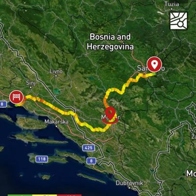
The route from Sarajevo to Mostar, if you take the E73, is probably one of the most scenic routes you can drive there.
First, you pass by Jablaničko Lake, a 30 km long reservoir, then you drive along the Neretva River through clusters of rocky formations until you reach Mostar.
While the route isn't particularly spectacular in terms of curves compared to some others, it offers consistently fantastic views.
Today I drove back into the EU, which meant passport control again. On the way into Bosnia, no one cared what kind of vehicle I was driving, but on the way back I had to show the papers — a German license plate alone wasn't enough to prove that the vehicle was from the EU.
In Croatia, I once again took some roads away from the main highways. At some point, I found myself on a road that was paved, but only wide enough for one vehicle, with some debris and a lot of vegetation on both sides.

22.05.25 Split - Dubrovnik
Distanz:
Reine Fahrzeit:
Gesamtfahrzeit:
The tracker is still malfunctioning; the information will be added later.
The distance from Split to Dubrovnik is just under 250 km, and for the most part, you can drive right along the water.
However, you should plan several hours for the trip, because for long stretches the speed limit is 60 km/h, so you don’t make very fast progress. If you value speed more than scenic views, the highway is probably the better option.
In good weather, the route invites you to make many stops at the numerous roadside parking bays to take photos. There are also plenty of options to take a longer break and relax a bit.
Thanks to the beautiful scenery, you sometimes lose track of how long you've already been driving, which can be dangerous in the towns you have to pass through along the way, because your concentration tends to slip.
©Urheberrecht. Alle Rechte vorbehalten.
Wir benötigen Ihre Zustimmung zum Laden der Übersetzungen
Wir nutzen einen Drittanbieter-Service, um den Inhalt der Website zu übersetzen, der möglicherweise Daten über Ihre Aktivitäten sammelt. Bitte überprüfen Sie die Details in der Datenschutzerklärung und akzeptieren Sie den Dienst, um die Übersetzungen zu sehen.